Sentinel satellite missions
Sentinel-1
Instrument: Synthetic Aperture Radar (SAR) in C-Band
Acquisition Modes: Stripmap (SM), Interferometric Wide swath (IW), Extra-Wide swath (EW), and Wave (WV)
Acquisition Date: April 2014 - present
Geographical Coverage: 90° N - 90° S
Polarisation: single (HH or VV) or dual polarisation (HH+HV or VV+VH)
| Processing Level | Pixel spacing | Product guide | Data Source | Citation |
|---|---|---|---|---|
| Single Look Complex (SLC) | 10 m (SM, IW) 20 m (EW) | Link | CDSE | Copernicus Sentinel data [year of data acquisition] |
| Ground Range Detected (GRD) | 10 m (SM, IW) 20 m (EW) | Link | CDSE | Copernicus Sentinel data [year of data acquisition] |
| Normalized Radar Backscatter (NRB) | 10 m (IW) 20 m (EW) | See below | DLR | German Aerospace Center (DLR) (2025): Sentinel-1 - NRB Level-1C - Global. https://doi.org/10.15489/4sc3nyjt0o76 |
Normalized Radar Backscatter (NRB)
This product contains geocoded radiometrically terrain corrected (RTC) gamma nought backscatter data () processed from Sentinel-1 GRD. The product specification and processor prototyping were originally contracted by ESA. Since then, DLR has further developed and operationalized the processor and has deployed it on terrabyte. All available GRD data acquired in interferometric wide swath mode (IW) is systematically processed. The usage of cloud-optimized GeoTIFFs for the binary data and comprehensive STAC metadata facilitate large-scale data cube exploitation. The product is compliant with the CEOS-ARD SAR NRB specification version 5.5, according to a self-assessment, but has not been reviewed or endorsed yet. Please find below an overview of key product characteristics.
| attribute | value |
|---|---|
| Processing Level | Level 1C |
| Spatial reference system | UTM/UPS |
| Gridding and tiling system | S2-MGRS |
| grid sampling | 10 m |
| Measured variable | gamma nought RTC (), linear scaling |
| Units | |
| Tile size | 109.8 x 109.8 km |
| Number of samples per tile | 10980 x 10980 |
| Polarizations | HH | VV | HH+HV | VV+VH |
| data volume (estimate) | 8 PB |
| data volume per tile (avg.) | 1.2 GB |
| data format | cloud-optimized GeoTIFF |
| compression | LERC-ZSTD |
| product landing page | https://doi.org/10.15489/4sc3nyjt0o76 |
Product naming
The S1-NRB product folder follows the following structure:
MMM_AA_NRB__LFPP_YYYYMMDDTHHMMSS_OOOOOO_DDDDDD_TTTTT_CCCC
| ID | ID description | Values / Examples | Comment |
|---|---|---|---|
| MMM | Mission | Allowed: S1A, S1B, S1C, S1D | |
| AA | Acquisition mode | Allowed: IW | |
| NRB | Product type | Fixed: NRB | Normalized Radar Backscatter |
| _ | Resolution class | Fixed: _ | No resolution class; constant resolution per acquisition mode |
| L | Processing Level | Fixed: 1 | Level-1C normalized backscatter |
| F | Product class | Fixed: S | SAR Standard |
| PP | Polarisation | Allowed: SH (Single HH polarisation), SV (Single VV polarisation), DH (Dual HH/HV polarisation), DV (Dual VV/VH polarisation) | |
| YYYYMMDDTHHMMSS | UTC start time | Example: 20201122T070809 | Time of the earliest acquired pixel in the grid cell; Format: year (YYYY), month (MM), day (DD), "T", hour (HH), minute (MM), second (SS) |
| OOOOOO | Absolute orbit number | Allowed: 000001-999999 (decimal) | Taken from originating GRD; identical for subsequently acquired (and mosaicked) GRDs |
| DDDDDD | Mission data take ID | Allowed: 000001-FFFFFF (hex) | Taken from originating GRD; identical for subsequently acquired (and mosaicked) GRDs |
| TTTTT | MGRS tile identifier | Example: 32TNS | |
| CCCC | Unique product identifier | Allowed: 0000-FFFF | A hexadecimal string generated by computing CRC-16 on a datetime string in ISO 8601 format. The CRC-16 algorithm used to compute the unique identifier is CRC-CCITT (0xFFFF). The datetime string is generated during processing and also stored in the product metadata files. |
A near-identical naming scheme is applied to the files in the product.
Backscatter file naming:
mmm-aa-nrb-yyyymmddthhmmss-oooooo-dddddd-ttttt-pp-c-sss.eee
| ID | ID description | Values /Examples | Comment |
|---|---|---|---|
| pp | Polarisation | Allowed: hh, hv, vv, vh, cc | Polarisation or "cc" for colour composite |
| c | Backscatter convention | Allowed: s, g | sigma nought RTC, gamma nought RTC |
| sss | Scaling | Allowed: lin, log | |
| eee | File extension | Allowed: tif, vrt |
Annotation file naming:
mmm-aa-nrb-yyyymmddthhmmss-oooooo-dddddd-ttttt-ff.eee
| ID | ID description | Values /Examples | Comment |
|---|---|---|---|
| ff | File identifier | Allowed: dm gs id lc li | data mask gamma-sigma ratio acquisition ID mask local contributing area local incident angle |
| eee | File extension | Allowed: tif, vrt |
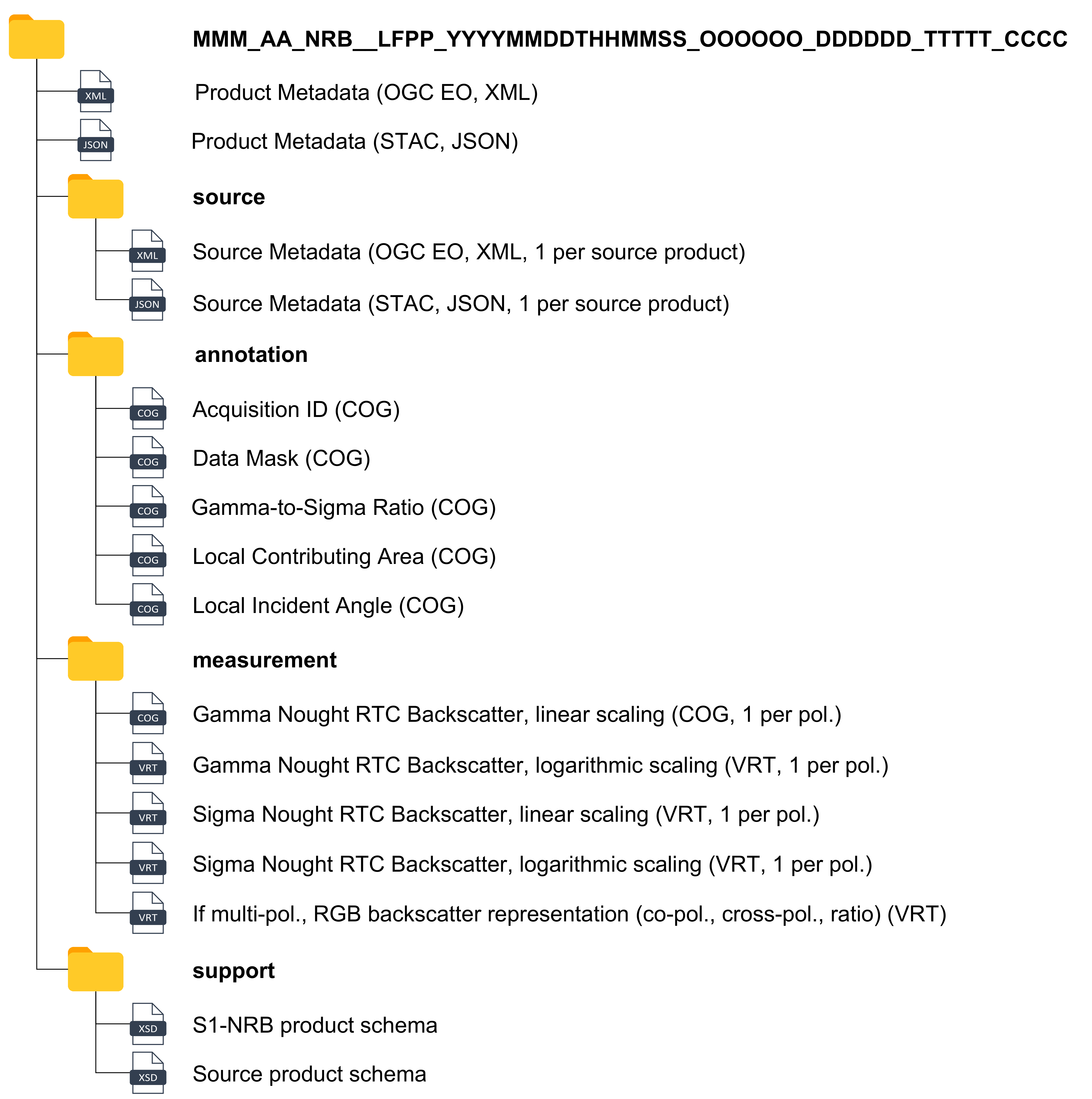
Data structure
The following gives an overview of all files that can be found in one S1-NRB product.
Data use
QGIS must be built with GDAL>=3.5.0 for LERC decompression and VRT on-the-fly computations.
A tutorial on data cube usage with STAC and dask is available here:
https://github.com/DLR-terrabyte/demo-bids23
software
Most software developed for S1-NRB processing is available on GitHub:
s1ard: main S1-NRB processor
https://github.com/SAR-ARD/s1ard
cesard: general ARD processing utilities
https://github.com/SAR-ARD/cesard
pyroSAR: SAR processing framework
https://github.com/johntruckenbrodt/pyroSAR
spatialist: spatial data handling
https://github.com/johntruckenbrodt/spatialist
Sentinel-2
Instrument: MultiSpectral Instrument (MSI)
Acquisition Date: July 2015 - present
Geographical Coverage: 84° N - 56° S
Spatial Resolution: 10 m - 60 m
Spectral Range: 0.49 - 2.20 µm (table with bandwidth)
| Processing Level | Atmospheric Processor | Product guide | Data Source | Citation |
|---|---|---|---|---|
| Level-1C | none | Link | CDSE | Copernicus Sentinel data [year of data acquisition] |
| Level-2A | Sen2Cor | Link | CDSE | Copernicus Sentinel data [year of data acquisition] |
| Level-2A | MAJA | S2 Product MAJA ATBD | DLR | DLR [year of acquisition] Sentinel-2 MSI - Level 2A (MAJA Tiles) |
Sentinel-3
Instruments:
- SRAL (Sentinel-3 Radar Altimeter)
- MWR (MicroWave Radiometer)
- OLCI (Ocean and Land Color Instrument)
- SLSTR (Sea and Land Surface Temperature Radiometer)
Acquisition Date: 2016 - present
Website: https://sentinels.copernicus.eu/web/sentinel/copernicus/sentinel-3
**Documentation: ** S3 Documents
Data Source: CDSE
Citation: Copernicus Sentinel data [year of data acquisition]
| Instrument | Product type | Product Type Description |
|---|---|---|
| OLCI | OL_1_EFR___ | Full Resolution TOA Reflectance |
| OL_1_ERR___ | Reduced Resolution TOA Reflectance | |
| OL_2_LFR___ | Full Resolution Land and atmosphere geophysical products | |
| OL_2_LRR___ | Reduced Resolution Land and atmosphere geophysical products | |
| OL_2_WFR___ | Full Resolution Water and Atmosphere geophysical products | |
| OL_2_WRR___ | Reduced Resolution Water and Atmosphere geophysical products | |
| SLSTR | SL_1_RBT___ | Brightness temperatures and radiances |
| SL_2_AOD___ | Aerosol Optical Depth | |
| SL_2_FRP___ | Fire radiative power | |
| SL_2_LST___ | Land surface temperature parameters | |
| SL_2_WST___ | Level-2P sea surface temperature (GHRSST-like) | |
| SYNERGY | SY_2_AOD___ | Global Aerosol parameter over land and sea on super pixel resolution (4.5 km x 4.5 km) |
| SY_2_SYN___ | Surface Reflectance and Aerosol parameters over Land | |
| SY_2_V10___ | 1 km VEGETATION-Like product (~VGT-S10) 10 day synthesis surface reflectance and NDVI | |
| SY_2_VG1___ | 1 km VEGETATION-Like product (~VGT-S1) 1 day synthesis surface reflectance and NDVI | |
| SY_2_VGP___ | 1 km VEGETATION-Like product (~VGT-P) - TOA Reflectance |
Sentinel-5P
Sentinel-5P has been studying the Earth's atmosphere since 2017. The TROPOMI instrument on board of Sentinel-5P measures the concentration of trace gases in the atmosphere. The data is used for air quality monitoring and for climate monitoring.
Instrument: TROPOspheric Monitoring Instrument (TROPOMI)
Acquisition Date: 2018 - present
Website: Sentinel-5P - Missions - Sentinel Online - Sentinel Online (esa.int)
Data Source: CDSE
Citation: Copernicus Sentinel data [year of data acquisition]
Level-1
Metadata Specification: Metadata specification for the TROPOMI L1b products
Product Readme File: S5P Mission Performance Centre Level 1b Readme
| Product Type | Product Type Description | Spectral range [nm] |
|---|---|---|
| L1B_IR_SIR | Irradiance product SWIR module | 2305-2385 |
| L1B_IR_UVN | Irradiance product UVN module | 270-775 |
| L1B_RA_BD1 | Radiance product band 1 (UV detector) | 270 - 300 |
| L1B_RA_BD2 | Radiance product band 2 (UV detector) | 300 - 320 |
| L1B_RA_BD3 | Radiance product band 3 (UVIS detector) | 320 - 405 |
| L1B_RA_BD4 | Radiance product band 4 (UVIS detector) | 405 - 500 |
| L1B_RA_BD5 | Radiance product band 5 (NIR detector) | 675 - 725 |
| L1B_RA_BD6 | Radiance product band 6 (NIR detector) | 725 - 775 |
| L1B_RA_BD7 | Radiance product band 7 (SWIR detector) | 2305-2345 |
| L1B_RA_BD8 | Radiance product band 8 (SWIR detector) | 2345-2385 |
Level-2
| Product Type | Product Type Description | Readme | Product User Manual |
|---|---|---|---|
| L2__AER_AI | Aerosol index product | PRF-AI | PUM-AI |
| L2__AER_LH | Aerosol layer height product | PRF-AI | PUM-LH |
| L2__CH4___ | Methane (CH4) vertical column | PRF-CH4 | PUM-CH4 |
| L2__CLOUD_ | Cloud parameters | PRF-CL | PUM-CL |
| L2__CO____ | Carbon monoxide (CO) total column | PRF-CO | PUM-CO |
| L2__FRESCO * | Cloud product | ||
| L2__HCHO__ | Formaldehyde (CH2O) vertical column | PRF-HCHO | PUM-HCHO |
| L2__NO2___ | Nitrogen dioxide (NO2) vertical column | PRF-NO2 | PUM-NO2 |
| L2__NP_BD3 | Suomi-NPP cloud product – band 3 | PRF-NPP | PUM-NPP |
| L2__NP_BD6 | Suomi-NPP cloud product – band 6 | PRF-NPP | PUM-NPP |
| L2__NP_BD7 | Suomi-NPP cloud product – band 7 | PRF-NPP | PUM-NPP |
| L2__O3____ | Ozone (O3) total vertical column | PRF-O3-NRTI PRF-O3-OFFL | PUM-O3 |
| L2__O3__PR | Ozone (O3) full vertical profile | PRF-O3_PR | PUM-O3_PR |
| L2__O3_TCL | Ozone (O3) tropospheric vertical column | PRF-O3_T | PUM-O3_T |
| L2__SO2___ | Sulphur dioxide (SO2) vertical column | PRF-SO2 | PUM-SO2 |
Further S5P documents can be found in the Document Library and in the S5P Products Overview.
(*) Note: by (political) decision, L2__FRESCO is no longer a L2 but AUX data for ESA / CDSE despite its nomenclature; within PDGS it remains a L2 candidate
Selected auxiliary data
| Product Type | Product Type Description | Product User Manual |
|---|---|---|
| AUX_CTMFCT | NO2 profile data from TM5 Model running in forecast mode | PUM |
| AUX_CTMANA | NO2 profile data from TM5 Model running in assimilation mode | PUM |